Unequal Industrial Zoning
Industrial zoning harms Dallas Black & Hispanic neighborhoods
Daniel & Beshara represent residents in and adjacent to industrial zoning. These residents are disproportionately Black and Hispanic. These residents are often burdened with the harms of adjoining industrial uses including pollution and harmful health effects.
The City of Dallas states that its zoning regulations work to safeguard the health, safety, and welfare of the public by dividing the City into certain zoning districts. A standard zoning principle is to protect single-family neighborhoods by prohibiting these residential neighborhoods from being located next to industrial zoning and industrial uses. The City of Dallas follows this zoning principle when it protects the City’s predominantly White non-Hispanic (White) residential neighborhoods. There is only one instance of a single-family zoned neighborhood next to heavy industrial zoning in a White neighborhood.
The City violates this zoning principle in Black and Hispanic neighborhoods where there are 49 locations of City of Dallas single-family zoning districts located next to heavy industrial zoning districts. There is nothing to protect the families in these Black and Hispanic neighborhoods from the adjacent industrial zoning and uses.
The overview of the City of Dallas two industrial zoning categories of Industrial Manufacturing (IM) and Industrial Research (IR) zoning by race of location shows the racial inequities. View the City of Dallas map showing overall industrial zoning by race below:

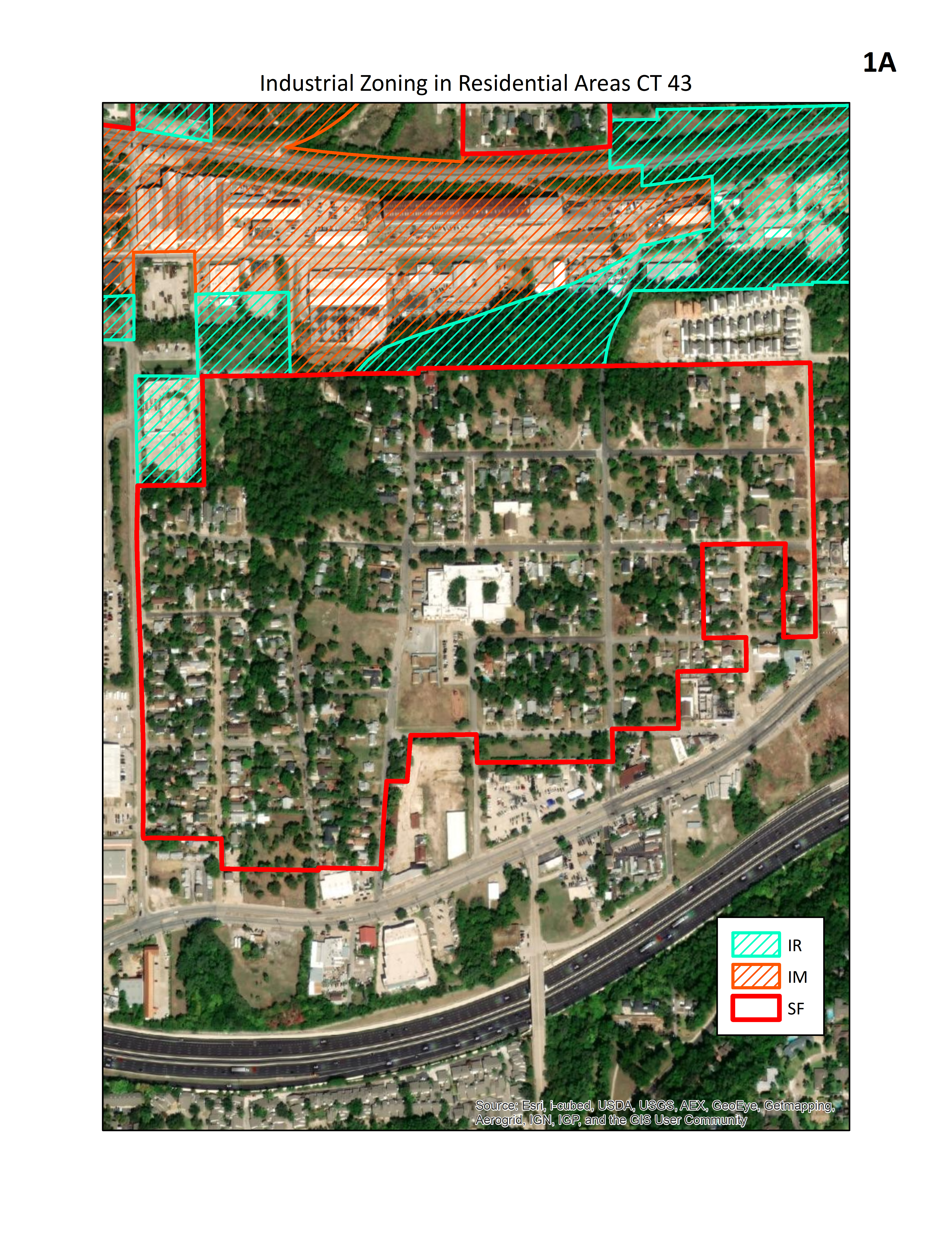
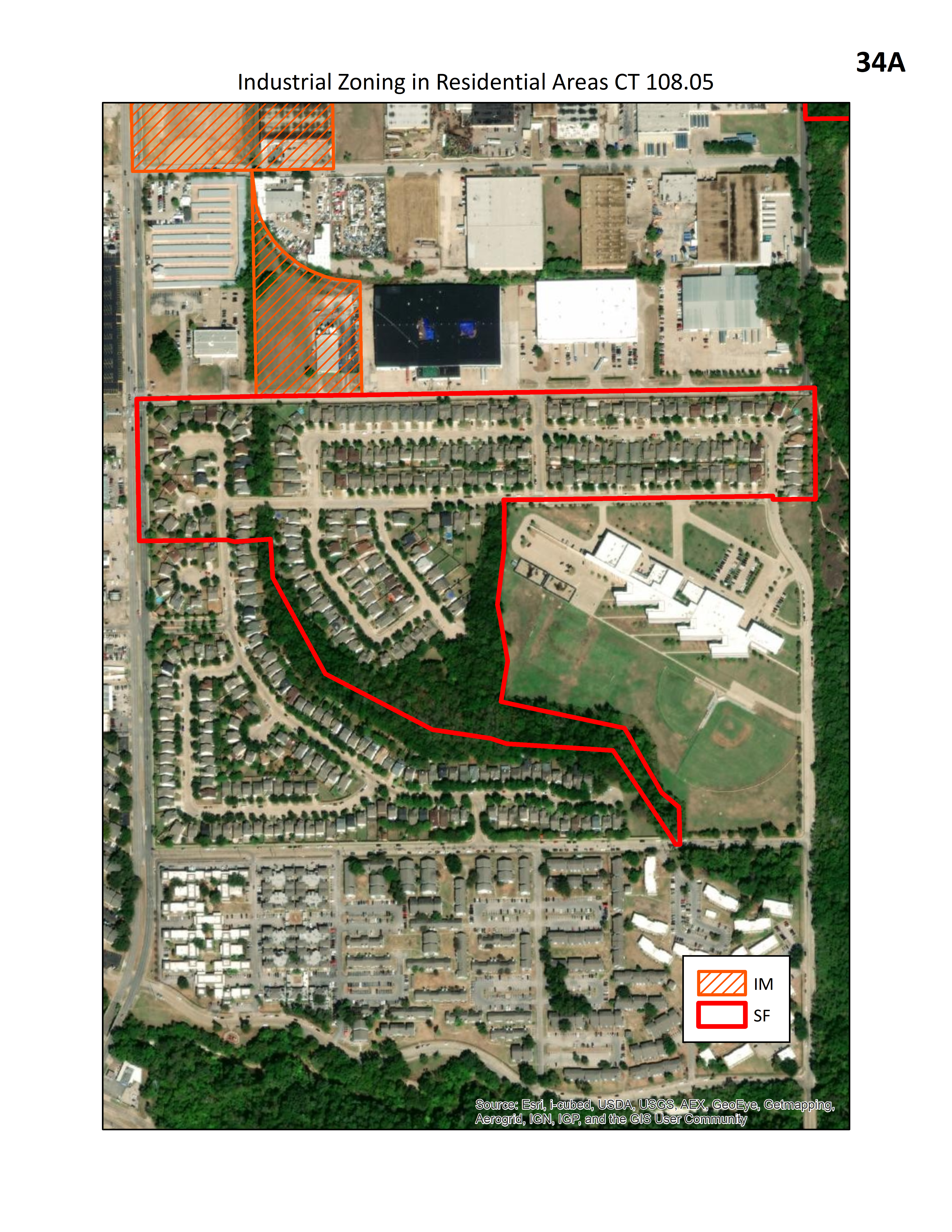
The following sets of maps show the racial inequities of the City of Dallas residential zoning located adjacent to heavy industrial zoning. The maps set out the single-family zoning districts and agricultural zoning districts adjacent to heavy industrial zoning (IM or IR zoning districts). The City has two categories of heavy industrial zoning – Industrial Manufacturing (IM) and Industrial Research (IR). There are two maps provided for each area – a satellite view and a street map view. The general region is provided as well as a more specific street location. Click here to view the region map [this map is Second - FINAL Industrial Zoning in Residential Areas Dallas Neighborhoods Map for website.png]

Index:
The 50 Maps Showing Locations in the Predominantly Black and Hispanic Neighborhoods of Single-Family Zoning Adjacent to Heavy Industrial Zoning (IM or IR or Both) are set out in the Gallery Maps below. To see the individual area click the Satellite and Street view for each below:
West Dallas - Fort Worth Avenue to Crownview between Vilbig and N Willomett - 1A (satellite) - 1B (street view)
West Dallas - Borger St - 2A (satellite) - 2B (street view)
West Dallas - East of Hampton Rd - 3A (satellite) - 3B (street view)
West Dallas - Mexicana Rd to I-30, between Loop 12 and Westmoreland - 4A (satellite) - 4B (street view)
West Dallas - West Dallas, Sylvan, Bayonne and Muncie - 5A (satellite) - 5B (street view)
SE Dallas - Dowdy Ferry Rd and LBJ - 6A (satellite) - 6B (street view)
SE Dallas - Elam and S Buckner - 7A (satellite) - 7B (street view)
SE Dallas - Far Southeast Dallas at 175 and I-20 - 8A (satellite) - 8B (street view)
SE Dallas - Hoyle to Military Parkway between S Buckner and Warrington - 9A (satellite) - 9B (street view)
SE Dallas - Joppa - 10A (satellite) - 10B (street view)
SE Dallas - Kleberg - Edd Rd and Pine Valley Dr - 11A (satellite) - 11B (street view)
SE Dallas - Kleberg area - 12A (satellite) - 12B (street view)
SE Dallas - Kleberg at S Beltline Rd - 13A (satellite) - 13B (street view)
SE Dallas - Kleberg at S Woody Rd - 14A (satellite) - 14B (street view)
SE Dallas - Kleberg- Hopeful Vista to Kleberg Rd - 15A (satellite) - 15B (street view)
SE Dallas - Samuel to 175, between S Buckner and railroad track - 16A (satellite) - 16B (street view)
SE Dallas - Scyene to Forney between N Prairie Creek Rd and S Buckner - 17A (satellite) - 17B (street view)
SE Dallas - Edd Rd and Foothill Dr. - 18A (satellite) - 18B (street view)
SE Dallas - St Augustine and LBJ - 19A (satellite) - 19B (street view)
SE Dallas - Shingle Mountain - 20A (satellite) - 20B (street view)
Oak Cliff - Bonnie View Rd to Cleveland - 21A (satellite) - 21B (street view)
Oak Cliff - Cadillac Heights - 22A (satellite) - 22B (street view)
Oak Cliff - E Overton to Kolsch, Fordham Rd - 23A (satellite) - 23B (street view)
Oak Cliff - Fordham, Kolloch, Ledbetter - 24A (satellite) - 24B (street view)
Oak Cliff - I-30 to W 6th, between Sylvan and Methodist Hospital. - 25A (satellite) - 25B (street view)
Oak Cliff - Illinois to Mayforge - 26A (satellite) - 26B (street view)
Oak Cliff - Loop 12 and I-45 - 27A (satellite) - 27B (street view)
Oak Cliff - N Denley to N Corinth between Canyon and Trinity River - 28A (satellite) - 28B (street view)
Oak Cliff - RedBird Area, between Cockrell Hill Rd and HWY 67 - 29A (satellite) - 29B (street view)
Oak Cliff - RedBird to Barstow between Cockrell Hill RD and Laramore - 30A (satellite) - 30B (street view)
Oak Cliff - Remond, N Hampton and Fullerton, Fort Worth Ave - 31A (satellite) - 31B (street view)
Oak Cliff - S Corinth and 11th - 32A (satellite) - 32B (street view)
Oak Cliff - S Hampton and Loop 12 - 33A (satellite) - 33B (street view)
Oak Cliff - Westmoreland and Hansboro - 34A (satellite) - 34B (street view)
NE Dallas - Audelia to Walnut, Skillman to Cross Creek - 35A (satellite) - 35B (street view)
NE Dallas - Hamilton Park - 36A (satellite) - 36B (street view)
NW Dallas - Bachman Lake - 37A (satellite) - 37B (street view)
NW Dallas - Between Denton Dr and Harry Hines, Gilford and Brockfield Ave - 38A (satellite) - 38B (street view)
NW Dallas - Brockbank and Walnut Hill - 39A (satellite) - 39B (street view)
NW Dallas - Denton Dr to Mohawk between Empire Central and Bombay - 40A (satellite) - 40B (street view)
NW Dallas - Newkirk St and Crown - 41A (satellite) - 41B (street view)
Central Dallas - Haskell to railroad track between Dophin Rd and Owenwood - 42A (satellite) - 42B (street view)
Central Dallas - I-30 to Forney Rd between Brennan and Boone - 43A (satellite) - 43B (street view)
Central Dallas - South Dallas - Between Scyene and Second Ave - 44A (satellite) - 44B (street view)
East Dallas - Casa View, Ferguson and LBJ - 45A (satellite) - 45B (street view)
SW Dallas - Duncanville Rd and Ranchero Lane - 46A (satellite) - 46B (street view)
SW Dallas - Kiest and Walton Walker - 47A (satellite) - 47B (street view)
SW Dallas - Margewood, Britt and Miller Dr - 48A (satellite) - 48B (street view)
SW Dallas - South of I-30 and East of Walton Walker. Includes Arcadia Park - 49A (satellite) - 49B (street view)
SW Dallas - West of Mt. Creek Lake - 50A (satellite) - 50B (street view)
THE ONE LOCATION IN A PREDOMINANTLY WHITE NON-HISPANIC NEIGHBORHOOD SHOWS SINGLE FAMILY ZONING ADJACENT TO INDUSTRIAL ZONING:
NE Dallas - Forest Lane and Shepherd Rd - 51A (satellite) - 51B (street view)
Note: In addition to Single-family zoning, Agriculture zoning also allows for single family uses. There is agriculture zoning with single family homes that is adjacent to heavy industrial zoning.